
We should have seen this coming – Google Street View will now offer a Virtual Reality experience. Google announced that they are providing full support for the use of Google Cardboard VR in Street View. It will add a new dimension to Google Maps and expand the entertainment and learning resources the Maps feature provides.
Google Street View Virtual Reality
Brandon Wuest, a Google Software Engineer and as he refers to himself, a “Stereoscopic Sightseer” (so wish I’d thought of that term), made the announcement on the Google Developers Blog:
Google Cardboard is bringing virtual reality worldwide. Starting today, the Google Cardboard app is available in 39 languages and over 100 countries on both Android and iOS devices. Additionally, the Cardboard developer docs are now published in 10 languages to help developers build great VR experiences. . . .
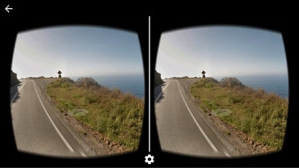
Finally, to help bring you to more places, you can now explore Google Street View in Cardboard. So, download the updated Google Street View app for Android or iOS, and grab your Cardboard to immerse yourself in destinations around the world.
Both of the development kits (SDKs) – for Android and Unity – were updated to lessen the visual distortion that was common in the selected Street View scenes that were previously available in virtual reality.
Street View continues to expand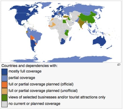
Street View continues to expand its coverage of the world and it’s value in our day-to-day lives. Digital Maps not only help us with directions, but we can now see our destination before we get there – or perhaps, even before we’ve made a reservation.
Indeed, Street View has killed off more than one potential hotel stay for me when I saw the location and opted for a more interesting area of a city. In the end, I had a better time by checking out the streets before I made my plans.
A valuable learning resource
Street View is an increasingly valuable academic resource for urban planning, sociology, ecology and other fields that make use of visual data from our surroundings. When Google announced last year that historical data would be included in Street View, it opened up a whole new dimension in the historical mapping of our visual experience.
I can look at my street now in New York City and see how it appeared five years ago. The changes aren’t significant now, but they will be as time progresses (even in an historical district where the buildings are preserved).
A century from now, the public may value this historical data in the same way that we look back on early photographic work like Matthew Brady’s images of the Civil War, seeing it as an essential resource.
Virtual reality is going to make Street View far richer as a learning resource and a much more interesting experience in general.
How far we’ve come in 8 years
Street View was announced on May 25, 2007, and became a full screen option in April 2009. User photos were added in June 2010 giving it a small crowdsourcing dimension. The historical data of prior Street View images was made available on April 23, 2014. Today, virtual reality. Tomorrow, we can only speculate on what the enhancements will bring.
We talk a lot about the data we will gain from the Internet of Things. But we’re not even there yet and the data is already pouring out from the Google apps in our smartphones. The only question is: how will we use it.
Emory Craig is a writer, speaker, and consultant specializing in virtual reality (VR) and generative AI. With a rich background in art, new media, and higher education, he is a sought-after speaker at international conferences. Emory shares unique insights on innovation and collaborates with universities, nonprofits, businesses, and international organizations to develop transformative initiatives in XR, GenAI, and digital ethics. Passionate about harnessing the potential of cutting-edge technologies, he explores the ethical ramifications of blending the real with the virtual, sparking meaningful conversations about the future of human experience in an increasingly interconnected world.