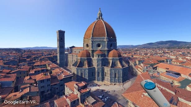
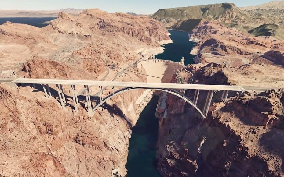
Google Earth VR was the surprise announcement on the Google Blog last week. Earth VR turns the entire world into a Virtual Reality playground and learning resource. It’s available for free in the Steam Store for the HTC Vive. Grab your headset, the Vive hand controllers and be ready for a breathtaking experience. Fly through a city, stand on a mountaintop, or plunge into the depths of a canyon.
Joe Durbin captures the essence of the experience in UpLoadVR.
I haven’t seen my hometown in almost a year but even the pull of nostalgia isn’t enough to keep me entertained forever. In the blink of an eye the world around me dissolves and the restaurants of East Fourth Street are replaced by the brilliant purple face of Japan’s Mt. Fuji. I aim for the lid of the famous mountain’s bowl-shaped depression and land smoothly on the craggy ground. Turning slowly I can almost feel the wind in my hair but I know that couldn’t be possible. This is not the real Mt. Fuji. This is Google Earth VR. And I never, ever want to leave.
You’re fluidly moving around the earth, not jumping from one point to the next, transporter style. The field of view narrows to counter the potential for motion sickness, but you can make adjustments in the FOV if you want the full experience.
Google’s very short promo video gives you a taste of what to expect:
Google Earth VR
Google’s new project is a stunning development for virtual reality. Or as Mashable put it:
. . . [It’s] the godlike virtual reality experience we’ve been waiting for.
What makes Earth VR so powerful is that it leverages the massive amount of data already collected for the Google Earth project. It’s a VR development without the release of new hardware. And there’s no need for a floor full of developers cranking out 3D objects in Unity.
Google Earth VR does not require an army of animators to build each building in San Francisco through Unity or Unreal Engine 4, it is fueled by an always refreshing data set from one of the world’s most powerful sources of geographical information. That type of power makes the full implications of Google Earth VR truly staggering.
More details to come
Despite the glowing reviews, there’s a few limitations at the moment. According to Mike Podwal, project manager for Google Earth VR,
. . . 94 percent of the world’s population is covered in this experience. 54 percent of the Earth’s land mass is covered. There are around 175 cities with full, 3D data, and over 600 ‘urban cores’ as well.
That’s impressive, but a good part of the earth’s land mass and lots of well-known cities are still missing. As you might expect, coverage of urban areas in the West is more extensive than cities in the rest of the world. And street names are missing with no way to type in an address. So while it’s easy to see a landmark, finding a street address will depend on your prior knowledge of a place.
But no matter – you’re going to have loads of fun getting there.
In addition, detailed areas are currently limited and they can warp and blur as you get closer to the ground. In UpLoadVR‘s memorable description, it has a bit of a Nintendo 64 aesthetic.
But that will change. Think back to those early versions of Google Maps or MapQuest that we once found so exciting and useful. This is just the first step to turning earth’s entire expanse into a virtual reality experience.
VR platforms and headsets
No word yet on when we’ll see Google Earth VR in other VR headsets. But Oculus Rift is a likely choice in the near future. But here’s where it gets interesting. What happens when this eventually comes to the low-priced Daydream View headset? Or a mid-range device that Google is rumored to be working on? At that point it will available to everyone just as Street View is today.
Think about the possibilities
Just consider a couple of the many possibilities here. Think about how the tourism industry will capitalize on this. Only recently have we been able to see a hotel room or a beach in a 360 photo before booking a trip. Now you will be able to virtually fly through a resort, or see a marketplace or historical district before your visit.
Housing developers will use it to showcase shopping and transit amenities in a neighborhood. And city planners can ditch their ubiquitous PowerPoints and use VR to demonstrate the impact of new projects.
And it will be an incredible resource in education. Students will have the opportunity to virtually travel to and study any place on earth. This is not the stationary experience of a 360 photo, but a deeply immersive encounter with a location. They could examine urban development in emerging global cities. Or study the rock formations in a canyon or the eroding coastline near an ocean.
We may not realize it now, but this could be a major step toward ending the traditional classroom as we know it.
These immersive experiences will become even more valuable if Google eventually adds the feature to turn back the clock that is now in Street View. As decades go by, we will be able to study how both the urban and natural worlds have changed through human actions and natural events.
Some of the reviews see this the “killer app” for VR. And at some point, having the entire world available in virtual reality may be the VR equivalent of email. It will just be part of our everyday experience. The term VR could even become a verb – “I’ll VR that to you before the meeting.” And who knows? A future generation may even grow weary of the experience. But right now, it is a fascinating development.
If you get the opportunity, try out Google Earth VR. Your world will never be the same.
Emory Craig is a writer, speaker, and consultant specializing in virtual reality (VR) and generative AI. With a rich background in art, new media, and higher education, he is a sought-after speaker at international conferences. Emory shares unique insights on innovation and collaborates with universities, nonprofits, businesses, and international organizations to develop transformative initiatives in XR, GenAI, and digital ethics. Passionate about harnessing the potential of cutting-edge technologies, he explores the ethical ramifications of blending the real with the virtual, sparking meaningful conversations about the future of human experience in an increasingly interconnected world.